Travel Guide
Rudranath: The Panch Kedar Temple Where the Himalayas Still Feel Untouched
Deep in the Garhwal Himalayas, past the last motorable road, Rudranath sits inside a natural rock cave where Shiva is worshipped as a face, not a form. No cable car, no shops, no crowds — just a three-day walk through oak forest and alpine meadow to one of the last untouched shrines of the Panch Kedar.
Opening note
There's a point on the trail past Panar Bugyal where the forest simply stops. One step you're under a canopy of oak and rhododendron, the next you're standing in an open meadow with Trishul and Nanda Ghunti filling the horizon, and the only sound is wind moving through grass that no road has ever reached. This is the walk to Rudranath — and it doesn't ease you in gently. There's no gradual reveal, no viewpoint with a parking lot. You earn every bit of it, one steep switchback at a time, and that's exactly why the people who make it still talk about it years later.
Orientation
Know the place
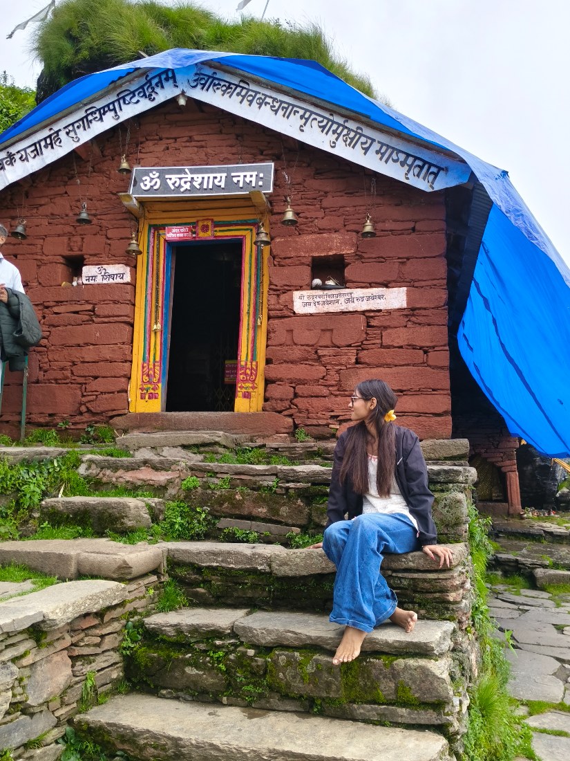
Rudranath is one of the five Panch Kedar temples of Uttarakhand, the shrines built where, according to legend, parts of Lord Shiva's body appeared after he tried to evade the Pandavas in the form of a bull. At Rudranath, it's his face — worshipped inside a natural rock cave at an altitude of roughly 3,600 metres (about 11,800 ft), making it the highest and most remote of the Panch Kedar sites after Kedarnath itself. The temple is ringed by four small sacred water bodies — Surya Kund, Chandra Kund, Tara Kund, and Mana Kund — and sits on a high ridge in Chamoli district with unobstructed views of Trishul, Nanda Devi, Nanda Ghunti, and Hathi Parvat.
There is no road to Rudranath. The nearest motorable point is Sagar village, and everything after that — roughly 20 to 22 km one way — is on foot.
02 · Why it matters
More than a point on the map
Compared to Kedarnath or even Tungnath, Rudranath has almost no infrastructure — no helicopter option, no pony trail, no shop-lined approach. That's not a gap; it's the point. The trek is widely considered the toughest of the five Panch Kedar routes, with a long, steep, continuous climb through dense forest before it breaks into the bugyals (alpine meadows) near the top. Along the way you pass through genuinely wild terrain — oak and rhododendron forest, grazing meadows, and finally Pitra Dhar, the highest point on the trail at close to 3,900 m, where small shrines to Parvati, Shiva, and Narayana look out over one of the widest Himalayan panoramas on any trek in the region. Because it demands more, it keeps out the crowds that have reshaped Kedarnath and Badrinath — Rudranath still feels like a pilgrimage rather than a tourist circuit.
Experiences
What stays with you
Trek to Pitra Dhar, the highest point of the route, for the widest panorama of the trip
Camp overnight at Panar Bugyal, one of the most scenic alpine meadows in the Garhwal Himalayas
Visit the four sacred kunds around the temple — Surya, Chandra, Tara, and Mana Kund
Attend the morning aarti at the temple before starting the descent
Pay respects at Gopinath Temple in Gopeshwar, Rudranath's winter seat, especially if visiting outside the May–November window
Extend the trip into a fuller Panch Kedar circuit by combining with Anusuya Devi Temple or Kalpeshwar
04 · Plan
Plan smart, travel easy
How to reach
By road
Follow the reviewed route shown above. Distances and travel time are guidance rather than live traffic information.
By train
The nearest railhead is Rishikesh (Yog Nagari Rishikesh Railway Station), around 210–240 km from Sagar village. Haridwar Junction, slightly further out, has better long-distance connectivity and is the more common starting point for visitors coming from Delhi.
By air
The nearest airport is Jolly Grant Airport in Dehradun, roughly 220–275 km from Sagar/Gopeshwar. From there it's a taxi or bus to Rishikesh/Haridwar and then onward along the same road route.
Best time to visit
May to June
The best window to visit. The temple's kapat (doors) typically open in mid-May, timed to Panchang calculations, with the idol brought up from its winter seat at Gopinath Temple in Gopeshwar in a multi-day procession. Days are pleasant (roughly 15–20°C), rhododendrons are still blooming lower on the trail, and this is peak trekking season.
July to August
Monsoon. Not recommended. The trail turns slippery, leeches are common in the forested sections, and landslides on the road route to Gopeshwar are a real risk. Best skipped entirely.
September to mid-November
The second-best window and arguably the best for mountain views, once monsoon clouds clear. Skies are sharpest in late September and October, days are cool and dry, and the peaks around Rudranath are at their most visible. The temple closes for winter around late October to mid-November With the exact date announced closer to the season — worth confirming before you plan a late trip.
December to April
Closed. Heavy snowfall makes the route inaccessible and the deity remains at Gopinath Temple in Gopeshwar through winter. Not a viable travel window.
People & place
Food and local culture
Sagar and Gopeshwar run on simple Garhwali fare — dal-chawal, aloo ke gutke, and rotis made with mandua (finger millet), a staple grain in this part of the hills that's dense enough to fuel a long trekking day. Once you're past Sagar, you're on whatever you or your guide's team carries in, so most trekkers eat basic camp meals — instant food, tea, and whatever dal-rice the trek cook manages at altitude. The forest checkpost at Sagar now charges a refundable plastic deposit on packaged food and bottles, a small but effective push toward keeping the trail litter-free. Local pujaris in Gopeshwar and Sagar are a good source of the region's Panch Kedar folklore if you have time to sit and talk before setting off.
Before you leave
Plan with care
Useful notes
- A forest entry permit is mandatory and issued at the checkpost in Sagar village — carry ID
- Carry cash; ATMs are scarce past Gopeshwar and network coverage is unreliable
- Budget 4–5 days rather than rushing the trek in 3 — the altitude gain (from ~2,000 m at Sagar to ~3,900 m at Pitra Dhar) needs proper acclimatization
- Hire a local guide from Sagar or Gopeshwar; the trail isn't signposted in most stretches
- Layer clothing — daytime sun at altitude can be strong, but temperatures drop fast after sunset even in May–June
- Start each day's trekking early; weather in this belt turns unpredictable by afternoon
Things to avoid
- Avoid the monsoon months (July–August) entirely — landslide risk on the approach road and leeches/slippery trail on the trek itself
- Don't skip acclimatization days; altitude sickness is the most common reason trekkers turn back
- There are no medical facilities beyond Gopeshwar — the nearest hospital is about 6 km from Sagar, and nothing beyond that until you're back down
- Watch for the early signs of AMS (persistent headache, nausea, loss of appetite) — descend if symptoms appear past Panar Bugyal rather than pushing on to Pitra Dhar
- Don't rely on mobile network past Sagar — inform someone of your itinerary before you start
07 · Make it yours
Suggested itinerary
- Day 1: Rishikesh/Haridwar → Sagar Village (drive, ~210–250 km, 7–9 hrs). Overnight in Sagar.
- Day 2: Sagar → Pung/Lyuti Bugyal → Panar Bugyal (trek, ~9–12 km). Camp at Panar.
- Day 3: Panar Bugyal → Pitra Dhar → Rudranath Temple (trek, ~8–10 km). Darshan, then return to Panar or overnight near the temple.
- Day 4: Panar Bugyal → Sagar Village (descend, ~12 km).
- Day 5: Sagar → Rishikesh/Haridwar (drive back).
A final note
Rudranath isn't a place you visit so much as a place you have to earn your way into — and that's precisely what's kept it from turning into another stop on a bus tour. If Kedarnath is the Panch Kedar shrine everyone knows, Rudranath is the one that still belongs mostly to the mountains. Go for the temple, but stay for the walk — the forest, the bugyals, and that one moment near Pitra Dhar where the whole Garhwal skyline opens up in front of you.
No approved comments yet. Be the first to share your thoughts.